By TAYLOR DAYTON
Arizona Sonora News
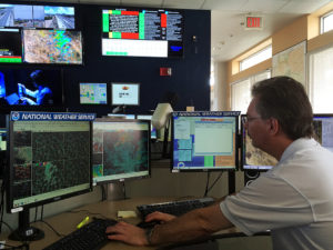
A group of attentive meteorologists hover at radar and satellite screens that make a colorful collage at the National Weather Service office in Tucson. On a breezy September afternoon, with a temperature of 93 degrees, monsoon thunderstorms dance across the desert sky in what could be their last gasp of the summer.
So another monsoon season was about to enter the book at the Tucson NWS. This one had rainfall above the average of 6.08 inches from June 15 to Sept. 30.
The operations center observes, records and predicts monsoon activity, and sends public warnings when storms become severe. Several meteorologists are anchored to workstations observing four or five monitors each on the third floor of a red-brick building at the University of Arizona. All have different radar and satellite images scanning southern Arizona for incoming thunderstorm threats. Although each meteorologist quietly goes about his or her respective duties, the hustle and bustle of the NWS office on a busy weather day almost imitates the faint sounds of thunder in the distance.
This is one of 122 NWS forecast centers around the country, where the nation’s 2,600 meteorologists work with local news media, emergency service personnel, forest rangers, transportation officials and agriculture and farm owners to protect the public. In southern Arizona, the sometimes violent monsoon season makes this work particularly important in terms of basic public safety.
“This monsoon season has had its own flavor and characteristics. They all do,” said Ken Drozd, one of the meteorologists. “We kicked off with the big storms in June, which is not typically that wet. July first was a big day, and the rest of July was dry until the end when it started again a little bit. August was really hit or miss.”
On this day, meteorologists watched a strong thunderstorm very closely as it moved north of Tucson toward the small community of Saddlebrooke. The radar estimated 2.5 inches of rain falling in a short period, so they issued a flash-flood warning for the streams and watersheds in the area. The warning gets automatically posted on the many radar and weather maps within the office and throughout the local networks. These warnings also notify the public via cell phones within the geographical area that has been warned.
September in Arizona has been active. Two tropical storms, Javier and Newton, boosted rainfall, and the “monsoon pattern,’ brought even more moisture north from Mexico.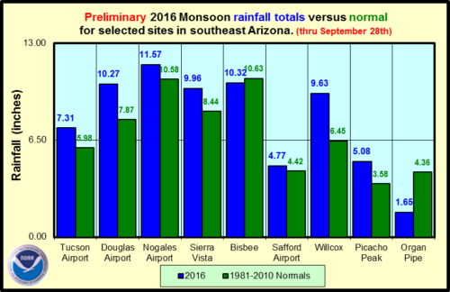
“I don’t like the term unpredictable, I like the term variable, because that is what best describes it,” Drozd said. “Every year it is variable, some places get hit really hard, and some places don’t get as much as far as rainfall goes. Some people have damage and most people won’t.”
Prediction even a day in advance can be hard. “You may think you known what is going to happen in the next couple days, but one day, just a little deviation in what happens today can greatly change tomorrow’s forecast.”
“Storms themselves are slow-moving and short-lived. They are not covering a large area, so if you don’t get hit, you luck out,” Drozd said.
He added: “2011 was kind of a dud year until Sept. 15. It was interesting because the sounding from the weather balloon looked very close to what yesterday’s did, but we had just one storm form and happened to sit right over the airport. They got about 3 inches at the airport.”
What would have been a below-average monsoon became the wettest September on record and an above average monsoon, all thanks to one storm that sat over the airport, which is the official rainfall recording location for Tucson.
It was also deadly. “All the water plowed into the Santa Cruz River. The river came up and there was a homeless guy down there,” Drozd said. “He climbed up on one of those pillars by the bridge. There was, like, 9 feet of water down there or more just gushing down the river. They threw him a rope to get him out and he missed it and he got swept downstream and died.”
Meteorologists rotate shifts to ensure that at least two meteorologists are monitoring the weather 24/7. When active weather is occurring, or expected, more meteorologists are called in to help.
On one of the many screens mounted on the walls of the office is a schedule of upcoming community events in which the NWS helps inform emergency managers of potential weather impacts. “Pima Country Fair starts Monday, we have it on a special calendar in case the emergency manager needs extra support,” Drozd said.
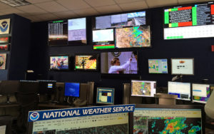
Local news media and broadcast meteorologists are key to helping protect the public. “They do coordinate with us,” he said, “and for significant events we try to get everybody in the same boat to keep a consistent message.”
KVOA News 4 Tucson’s Meteorologist Jeff Beamish highly values the collaborative relationship shared with the NWS and local networks.
“NWS data is vital to our day-to-day job. They supply us with current data, watches and warnings. We help them out with viewer storm reports, which help them verify the products they issue. We bat forecast reasoning off them & vice versa. It’s an incredible relationship we’re lucky to have,” Beamish said.
“It is very important for people who are making plans like emergency planners, emergency management and public safety folks, because if they can get an accurate forecast at least an idea of the range of possibilities that could happen four, five, six, seven days in the future, they can make plans. That is a lot of what we are doing now and in the future, and a lot of that the public never sees,” Drozd said.
The Arizona Department of Transportation is one of the many organizations that rely upon data from the NWS. “ADOT works with the NWS in a collaborative effort to better respond to adverse weather conditions,” said Kimberly Campbell, an emergency manager for ADOT.
“In Arizona this includes conditions such as monsoon rains, flooding, dust events, winter storm management, to wildfire response.”
“If we have a cold winter storm that comes in that predicts early rain, lowering temperatures and heavy snow, based on the NWS spot forecast, ADOT maintenance operations folks can pretreat the roads with anti-icing and de-icing agents that best fit the weather model including temperatures and precipitation amounts,” said Campbell, referring to the invaluable relationship between ADOT and NWS.
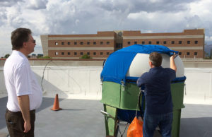
One tool used to help predict weather patterns is a radiosonde, a small radio transmitter which sends weather data from the atmosphere to the NWS. The radiosonde is attached to a large, helium-inflated rubber weather balloon and launched into the atmosphere twice daily. At the Tucson office, weather balloons are launched at 4am and 4pm from the rooftop of the NWS offices, in the Environment and Natural Resources building at UA.
The weather balloon goes up to about 100,000 feet in the atmosphere in about 90 minutes and the attached radiosonde transmits weather data back to the computer software at the NWS office. This process is done around the world at the same time, and all the weather data is linked together and input into computer models. This creates a vast network of data used to predict and view current and future weather patterns across the globe.
Jeff Davis, another meteorologist with the National Weather Service, prepares to launch the weather balloon as he inspects the inflated weather balloon, the attached radiosonde and parachute before launching.
“I did this years ago, and 27 years later they are having me do it again,” he said.
The balloon rapidly rises into the cloud-filled sky and recedes from view.
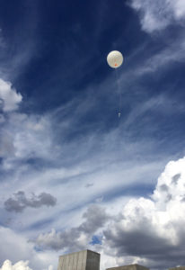
“Successful release,” he said.
Davis runs back downstairs to make sure atmospheric information is being transmitted back to the computer in the weather office. He examines a Skew-T diagram to analyze data being sent from the radiosonde on the balloon.
Weather balloon data has not always been so easy to capture.
“In the old days,” Davis said, “we had a big old computer that had the actual tapes that had a little chart and an ink pin. It would follow the trace of it and then you had to pick out the important weather features and code it.”
Davis is not alone in recognizing the ease technology has brought to the forecasting table. NWS offices nationwide have seen a tremendous improvement in weather forecasting over the past 20 years.
“Technology has certainly changed weather forecasting over the years! All these informational, processing and communications improvements have resulted in forecasts being more accurate (more precise over space and time) than ever,” Drozd said.
“For example the forecast several days in advance is now generally as accurate as the forecast for tomorrow was 20 years ago.”
Drozd says there is always plenty of weather to forecast even in southern Arizona, a place that receives about 285 days of sunshine a year. During the nicer weather, there’s still work.
“We are still forecasting fire weather conditions,” he said. “When it is not raining, it’s fire weather. You know it is going to be dry, but there are wind issues so there is wind forecasting. There is blowing dust issues to worry about, sometimes even freeze considerations for agriculture. Then you have the extreme heat as well.”
Download high resolution images here.
